


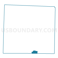
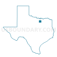
Voting District 0317, Denton County, Texas
About
Outline

Summary
| Unique Area Identifier | 672579 |
| Name | Voting District 0317 |
| County | Denton County |
| State | Texas |
| Area (square miles) | 4.89 |
| Land Area (square miles) | 4.76 |
| Water Area (square miles) | 0.14 |
| % of Land Area | 97.21 |
| % of Water Area | 2.79 |
| Latitude of the Internal Point | 33.00586880 |
| Longtitude of the Internal Point | -97.06206580 |
Maps

Graphs
Select a template below for downloading or customizing gragh for Voting District 0317, Denton County, Texas


Neighbors
Neighoring Voting District (by Name) Neighboring Voting District on the Map
- Voting District 0303, Denton County, TX
- Voting District 0320, Denton County, TX
- Voting District 0321, Denton County, TX
- Voting District 0409, Denton County, TX
- Voting District 0424, Denton County, TX
- Voting District 0425, Denton County, TX
- Voting District 3321, Tarrant County, TX
- Voting District 4708, Dallas County, TX
Top 10 Neighboring County Subdivision (by Population) Neighboring County Subdivision on the Map
- Southwest Dallas CCD, Dallas County, TX (912,166)
- Northeast Tarrant CCD, Tarrant County, TX (525,576)
- Lewisville-Flower Mound CCD, Denton County, TX (233,616)
Top 10 Neighboring Place (by Population) Neighboring Place on the Map
Top 10 Neighboring Unified School District (by Population) Neighboring Unified School District on the Map
- Lewisville Independent School District, TX (267,943)
- Grapevine-Colleyville Independent School District, TX (74,409)
- Coppell Independent School District, TX (44,419)
Top 10 Neighboring State Legislative District Lower Chamber (by Population) Neighboring State Legislative District Lower Chamber on the Map
- State House District 98, TX (239,343)
- State House District 63, TX (218,386)
- State House District 115, TX (140,868)
Top 10 Neighboring State Legislative District Upper Chamber (by Population) Neighboring State Legislative District Upper Chamber on the Map
Top 10 Neighboring 111th Congressional District (by Population) Neighboring 111th Congressional District on the Map
Top 10 Neighboring Census Tract (by Population) Neighboring Census Tract on the Map
- Census Tract 1137.03, Tarrant County, TX (9,179)
- Census Tract 217.53, Denton County, TX (5,089)
- Census Tract 217.27, Denton County, TX (4,402)
- Census Tract 200, Dallas County, TX (4,262)
- Census Tract 217.50, Denton County, TX (3,890)
- Census Tract 217.30, Denton County, TX (3,637)
- Census Tract 217.26, Denton County, TX (3,096)
- Census Tract 217.29, Denton County, TX (2,892)
- Census Tract 217.28, Denton County, TX (1,710)